

Sea Surface Height Measurement and Remote Sensing Using Android Smartphone
-
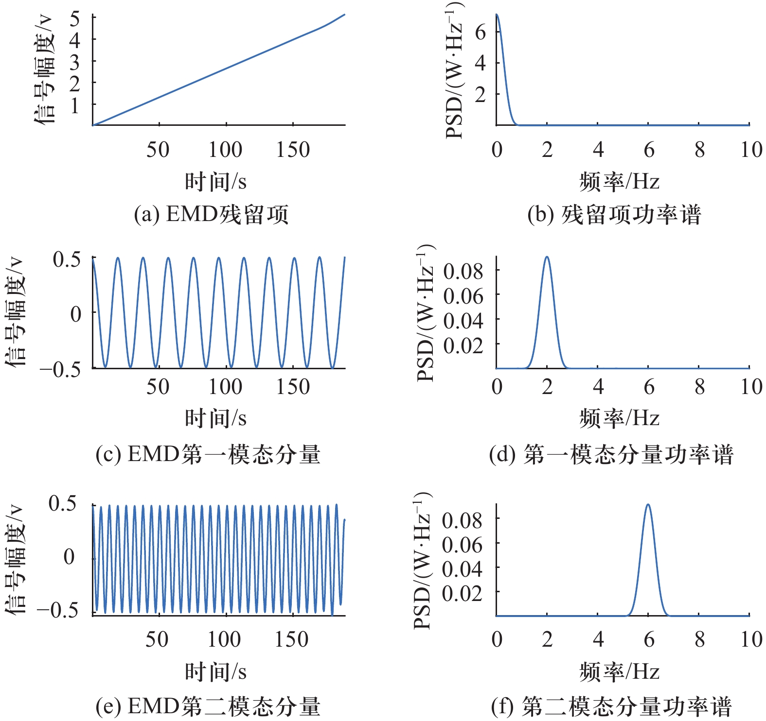
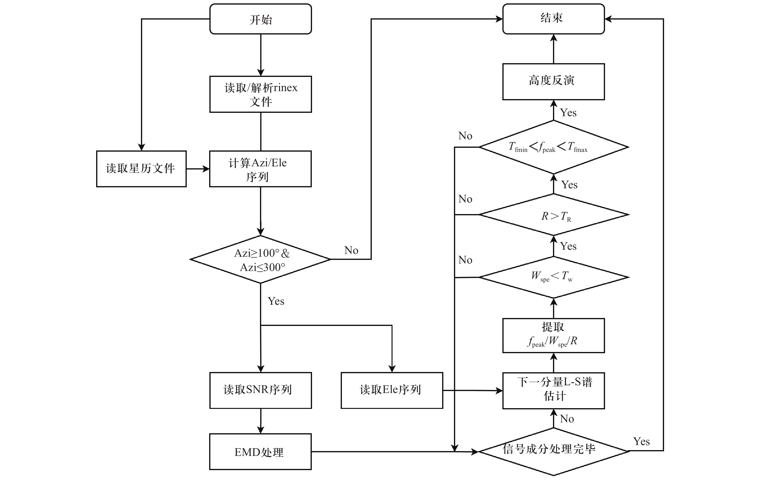
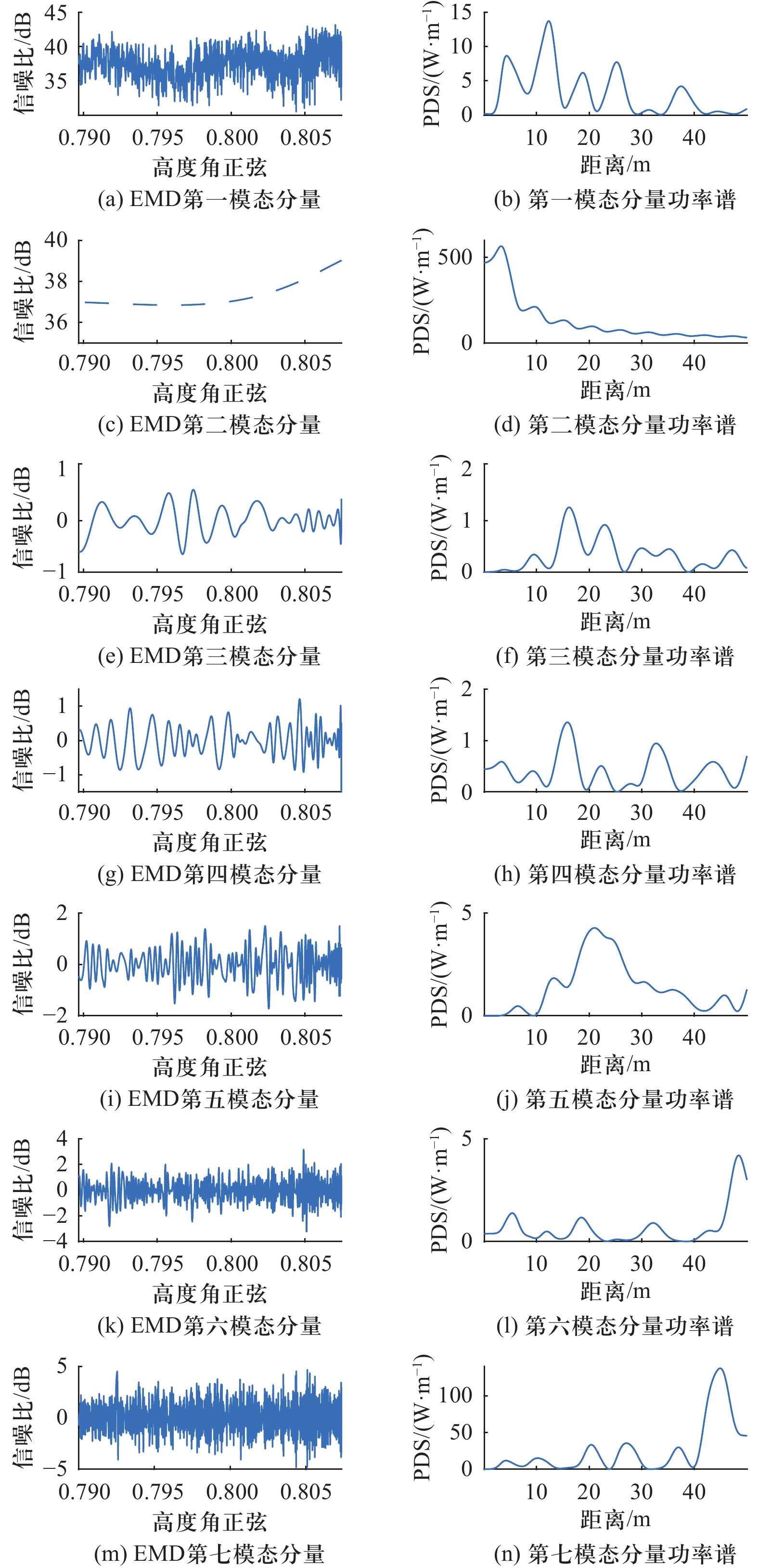
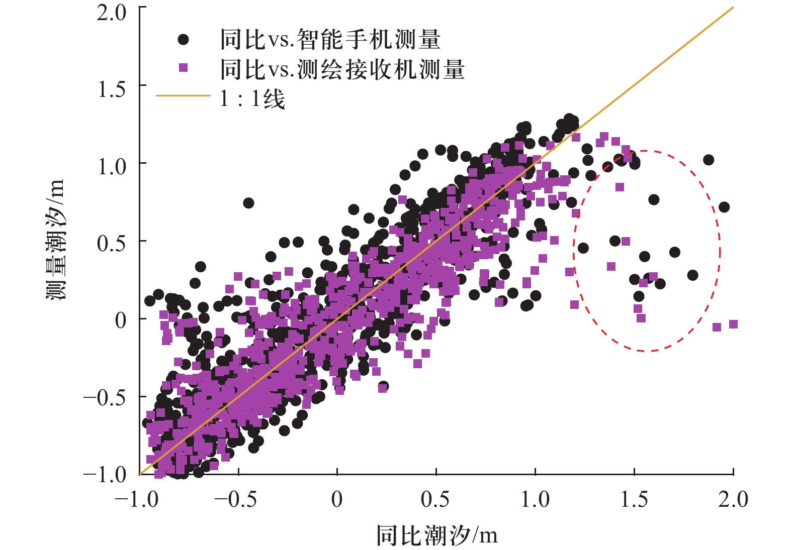
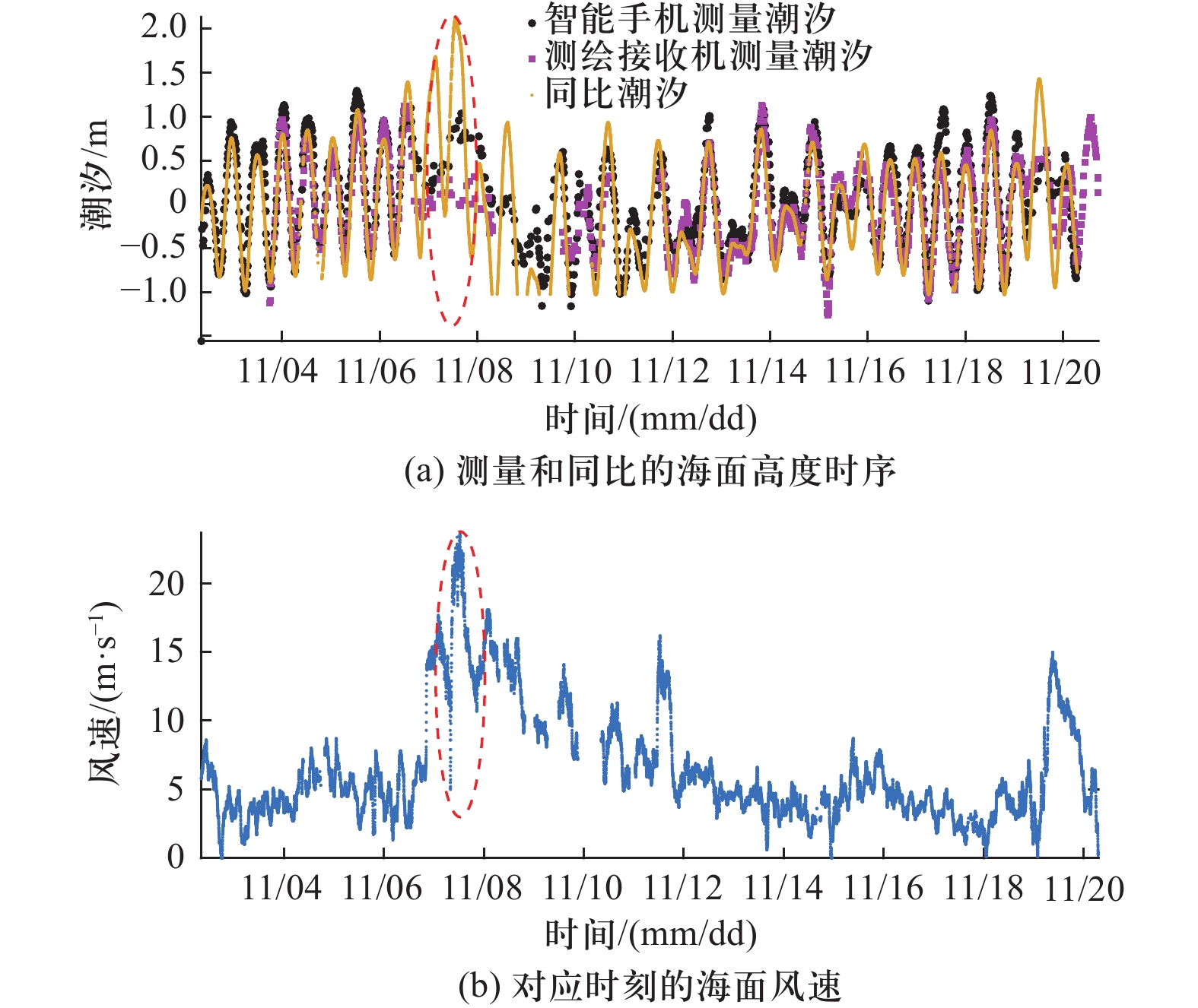
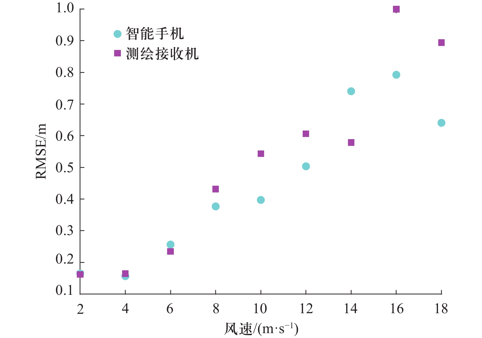
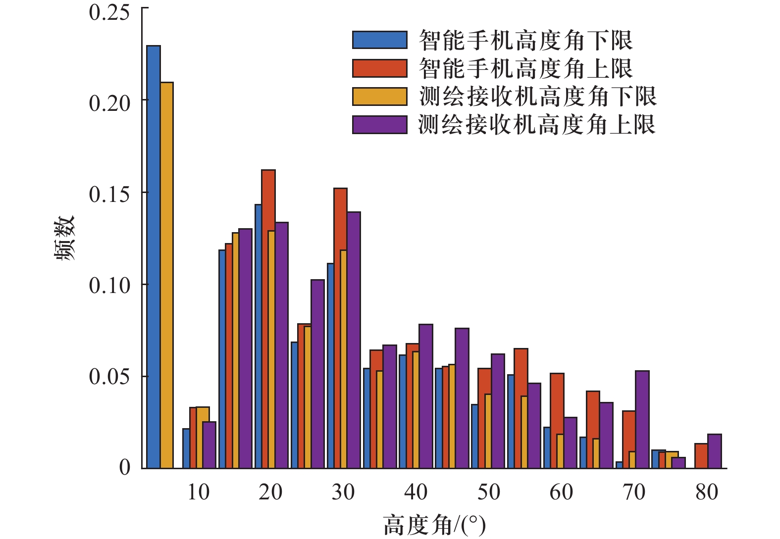
摘要:开展了Android智能手机的海面高度测量研究,并通过与测绘接收机测量结果和同比验潮站数据对比初步评估其性能。为了降低测量设备非探测区域反射的卫星导航信号对海面高度测量的影响,提出了经验模态分解提纯海面反射信号干涉振荡特征的方法,并利用仿真和试验数据验证了其有效性. 利用小米6智能手机和华测北斗N72测绘接收机采集的18天GNSS数据,开展了海面高度测量研究和评估. 结果表明:海面高度测量结果和验潮站同比数据在风速小于15 m/s时具有良好的一致性,智能手机和测绘接收机测量的海面高度的同比均方根误差均为0.31 m;智能手机用于测量海面高度的卫星信号的高度角下、上限高于30°的占比分别为30.8%和45.3%,以至于高高度角的信噪比时序可被用于测量海面高度;在18天的试验时间内,共计采集1120个海面高度测量值,平均62个/天,相比于CORS站,在相同的观测周期内具有更多的测量样本。最后对智能手机的遥感应用进行了讨论,以期推进遥感的大众化进程.
-
关键词:
- 安卓智能手机/
- 测绘接收机/
- GNSS-I/MR技术/
- 经验模态分解/
- 海面高度
Abstract:In this paper, the sea surface height measurement was explored based on Android smartphone, assessing its performance initially through comparing the measured sea surface height from Android and geodetic receiver to the data in situ. In order to weaken the influence of the signals from the non-observation areas on the measurement of sea surface height, an empirical mode decomposition (EMD) was proposed to extract the oscillation feature from the signal reflected off sea surface. And simulation and experiment were carried out to demonstrate its significance. The GNSS data collected by Xiaomi 6 smartphone and Huace BeiDou N72 geodetic receiver in 18 days were conducted to measure sea surface height and assess the performance. The experimental results show that, when wind speed is below 15 m/s, the measured sea surface heights from smartphone and geodetic receiver are agreement with in-situ ones from tide gauge, both with the root mean square error (RMSE) of 0.31 m. There are 30.8% and 45.3% lower and upper bound of the elevation angle of the GNSS signals to be over 30°, so that Signal-to-Noise Ratio (SNR) with higher elevation angle can be used to measure sea surface height. During the experiment within 18 days, 1120 in total and 62 measurements each day are obtained, therefore, in the same measurement period, compared to CORS station, more measurements can be obtained. In addition, the remote sensing was also discussed based on smartphone to promote the practicality of generally public remote sensing. -
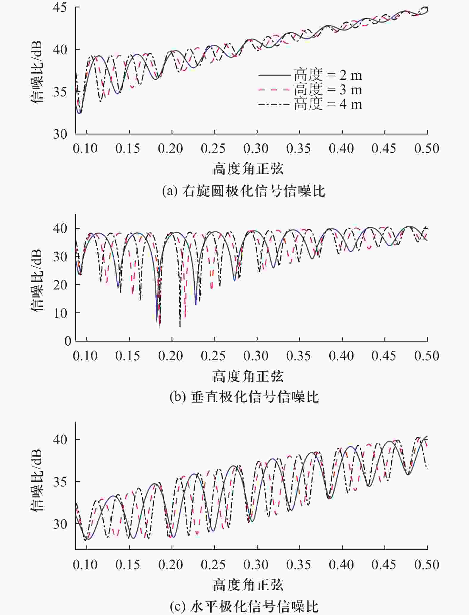
图 2右旋圆极化、垂直极化和水平极化信号信噪比随高度角正弦的变化
Figure 2.Right-handed circular polarization, vertical and horizontal SNR versus sine of elevation angle

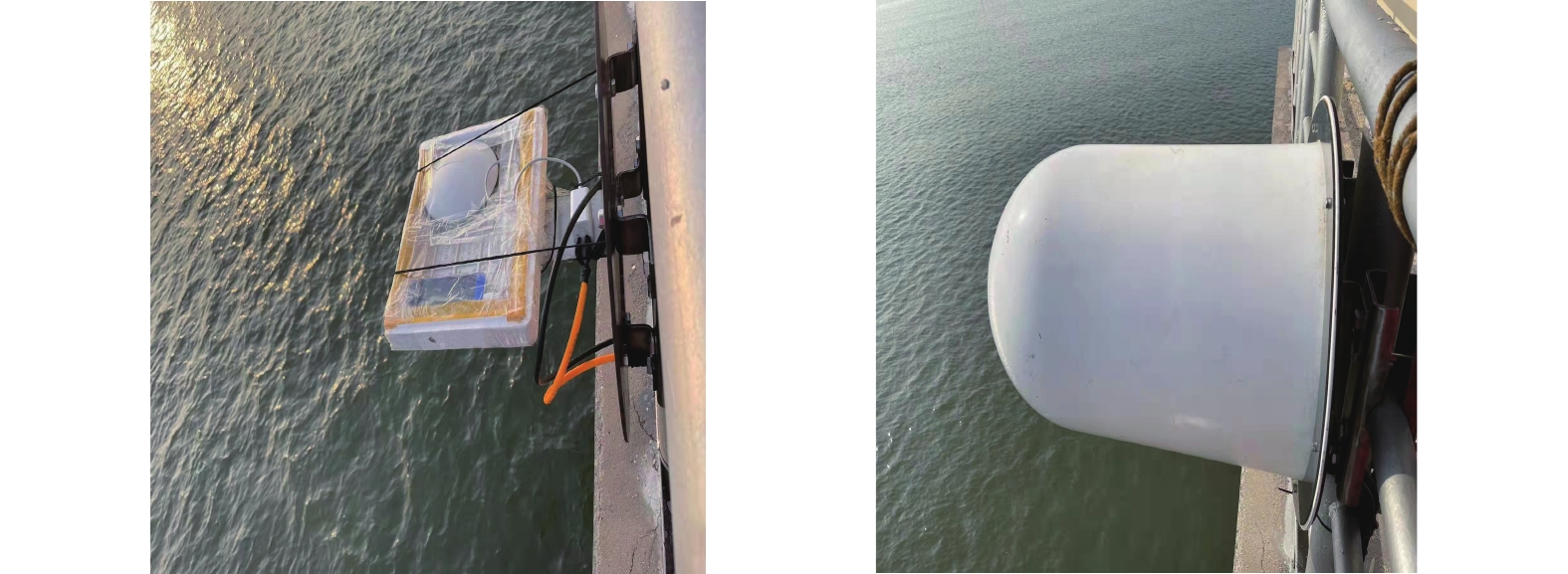
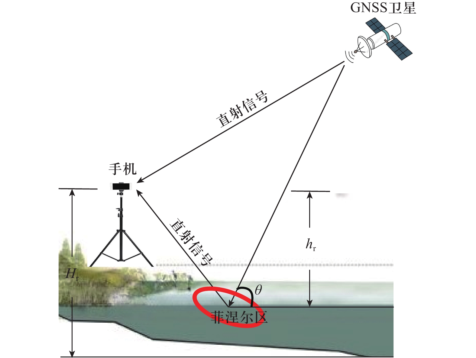
图 5智能手机测量海面高度验证试验场景
Figure 5.Experiment scenario of sea surface height measurement using smartphone
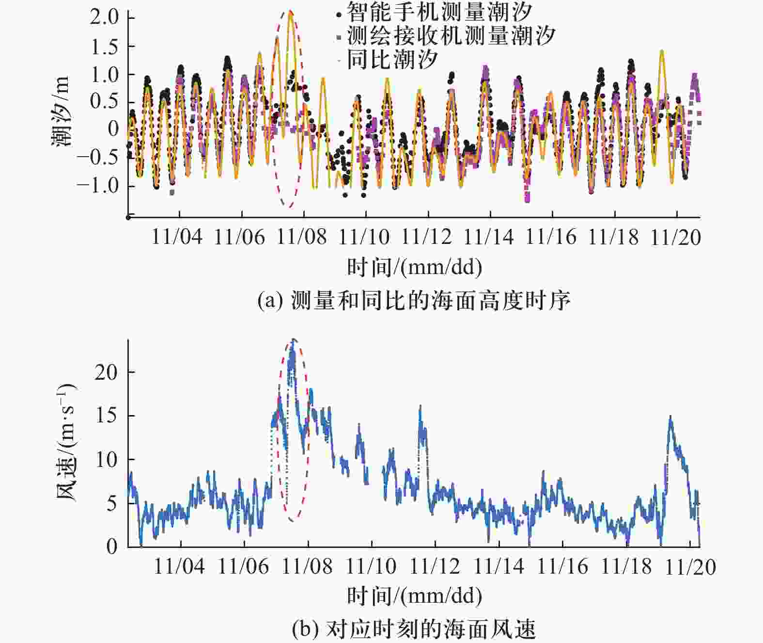
图 9测量和同比海面高度的时序及相应时刻的海面风速
Figure 9.Time series of measured and in-situ sea surface height, and corresponding sea surface wind speed
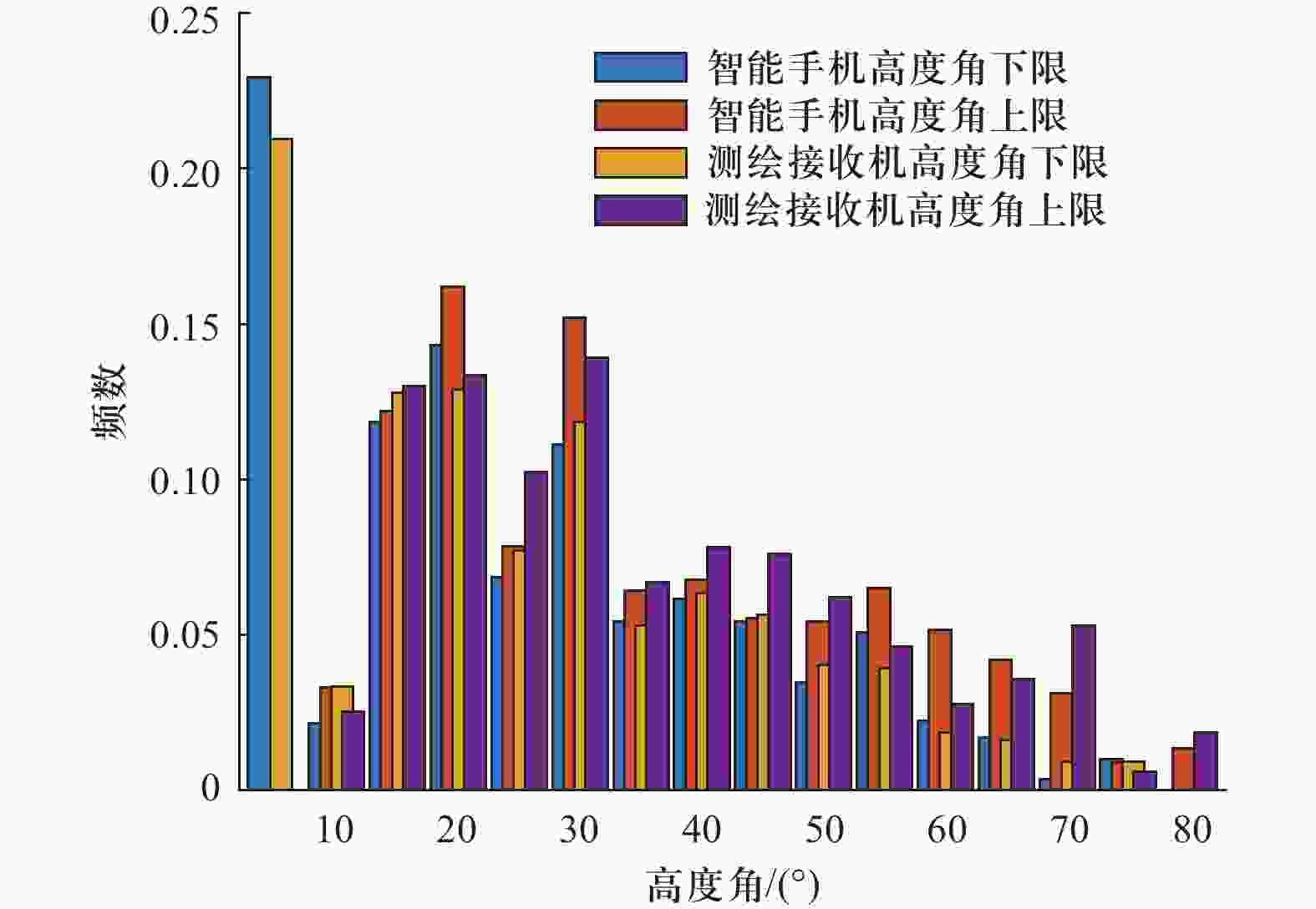
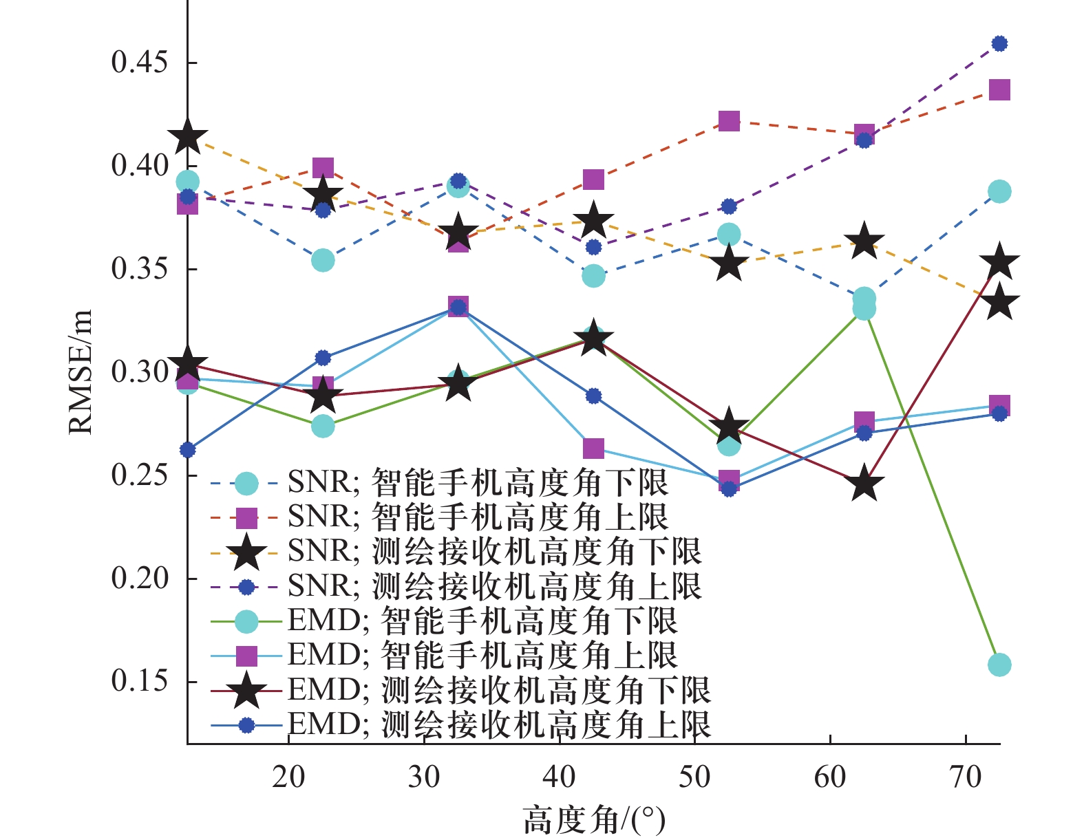
图 11测量样本在不同高度角的统计结果
Figure 11.Statistical results of measured samples at different elevation angles
-
[1] NEUMANN B, VAFEIDIS A, ZIMMERMANN J. Future coastal population growth and exposure to sea level rise and coastal flooding-a global assessment[J]. Plos One, 2015, 10(3): e0131375. [2] 文汉江, 金涛勇, 朱广彬. 卫星测高原理及应用[M]. 北京: 测绘出版社, 2017.WEN Hanjiang, JIN Taoyong, ZHU Guangbin. Principle and application PF satellite altimetry[M]. Beijing: Surveying and Mapping Publishing House, 2017.(in Chinese) [3] 米银霞. 卫星雷达高度计的海洋参数反演与近海重跟踪算法研究[D]. 武汉: 华中科技大学, 2019.MI Yinxia. The study on ocean parameter inversion and offshore retracking based on satellite radar altimeter[D]. Wuhan: Huazhong University of Science and Technology, 2019. (in Chinese) [4] 王强, 杨东凯, 修春娣, 等. 基于SVM的GNSS-R探测有效波高方法[J]. bob手机在线登陆学报, 2019, 39(增刊 2): 24 − 28.WANG Qiang, YANG Dongkai, XIU Chundi, et al. Significant wave height retrieval method based on support vector machine using gnss reflected signals[J]. Transations of Beijing Institute of Technology, 2019, 39(suppl 2): 24 − 28. (in Chinese) [5] 洪学宝, 张波, 杨东凯, 等. 地基GNSS-R功率测量应用中的天线方向性影响分析[J]. bob手机在线登陆学报, 2021, 41(6): 658 − 664.HONG Xuebao, ZHANG Bo, YANG Dongkai, et al. Antenna directivity effect analysis for ground-based gnss-r power measurement application[J]. Transactions of Beijing Institute of Technology, 2021, 41(6): 658 − 664. (in Chinese) [6] 李惟, 朱云龙, 王峰. GNSS多径信号模型及测高方法[J]. 北京航空航天大学学报, 2018, 44(6): 1239 − 1245.LI Wei, ZHUN Yunlong, WANG Feng. GNSS multipath signal model and altimetry method[J]. Journal of Beijing University of Aeronautics and Astronautics, 2018, 44(6): 1239 − 1245. (in Chinese) [7] 王笑蕾, 何秀凤, 陈殊, 等. 地基 GNSS-IR风速反演原理及方法初探[J]. 测绘学报, 2021, 50(10): 1298 − 1307.doi:10.11947/j.AGCS.2021.20200586WANG Xiaolei, HE Xiufeng, CHEN Shu. et. al. Preliminary study on theory and method of ground-based GNSS-IR wind speed[J]. Acta Geodaetica et Cartographica Sinica, 2021, 50(10): 1298 − 1307. (in Chinese)doi:10.11947/j.AGCS.2021.20200586 [8] ROGGENBUCK O, REINKING J, LAMBERTUS T. Determination of significant wave heights using damping coefficients of attenuated GNSS SNR data from static and kinematic observations[J]. Remote Sensing, 2019, 11: 409. [9] STRANDBERG J, HOBIGER T, HAAS R. Coastal sea ice detection using ground-based GNSS-R[J]. IEEE Geoscience and Remote Sensing Letters, 2017, 14(9): 1552 − 1556. [10] 汉牟田, 张波, 杨东凯, 等. 利用GNSS干涉信号振荡幅度反演土壤湿度[J]. 测绘学报, 2016, 45(11): 1293 − 1300.doi:10.11947/j.AGCS.2016.20160145HAN Moutian, ZHANG Bo, YANG Dongkai, et al. Soil moisture retrieval utilizing GNSS interference signal amplitude[J]. Acta Geodaetica ET Cartographica Sinica, 2016, 45(11): 1293 − 1300. (in Chinese)doi:10.11947/j.AGCS.2016.20160145 [11] LARSON K M, SMALL E E. Normalized microwave reflection index: a vegetation measurement derived from GPS networks[J]. IEEE Journal of Selected Topics in Applied Earth Observations and Remote Sensing, 2014, 7(5): 1501 − 1511.doi:10.1109/JSTARS.2014.2300116 [12] 少锋, 周威, 刘立龙, 等. 小波变换与滑动窗口相结合的GNSS-I雪深估测模型[J]. 测绘学报, 2020, 49(9): 1179 − 1188.doi:10.11947/j.AGCS.2020.20200268SHAO Feng, ZHOU Wei, LIU Lilong, et. al. GNSS-IR model of snow depth estimation combining wavelet transform with sliding window[J]. Acta Geodaetica et Cartographica Sinica, 2020, 49(9): 1179 − 1188. (in Chinese)doi:10.11947/j.AGCS.2020.20200268 [13] STRANDERG J, HOBIGER T, HASS R. Real-time sea-level monitoring using Kalman filtering of GNSS data[J]. GPS Solutions, 2019, 23: 61. [14] 何秀凤, 王杰, 王笑蕾, 等. 利用多模多频GNSS-IR 信号反演沿海台风风暴潮[J]. 测绘学报, 2020, 49(9): 1168 − 1178.HE Xiufeng, WANG Jie, WANG Xiaolei, et. al Retrieval of coastal typhoon storm surge using Multi-GNSS-IR[J]. Acta Geodaetica et Cartographica Sinica, 2020, 49(9): 1168 − 1178. (in Chinese) [15] KIM S K, PARK J. Monitoring a storm surge during hurricane Harvey using multi-constellation GNSS-Reflectometry[J]. GPS Solutions, 2021, 25(2): 63.doi:10.1007/s10291-021-01105-2 [16] FAGUNDES M R R, TMENDOCA-TINTI I, IESCHECK A K, et al. An open-source low-cost sensor for SNR-based GNS reflectometry: design and long-term validation towards sea-level altimetry[J]. GPS Solutions, 2021, 25: 73. [17] PURNELL D J, GOMES N, MINARIK W, et al. Precise water level measurements using low-cost GNSS antenna arrays[J]. Earth Surface Dynamics, 2021, 9: 673 − 685. [18] MALKOS S. User location takes center in new android OS: Google to provide raw GNSS measurement[J]. GPS World, 2016, 27(7): 36. [19] 高成发, 陈波, 刘永胜. Android智能手机GNSS高精度实时动态定位[J]. 测绘学报, 2021, 50(1): 18 − 26.doi:10.11947/j.AGCS.2020.20200107GAO Chengfa, CHEN Bo, LIU Yongsheng. Android smartphone GNSS high-precision real-time dynamic positioning[J]. Acta Geodaetica ET Cartographica Sinica, 2021, 50(1): 18 − 26. (in Chinese)doi:10.11947/j.AGCS.2020.20200107 [20] ALTUNTA C, TUNALIOGLU N. Feasibility of retrieving effective reflector height using GNSS-IR from a single-frequency android smartphone SNR data[J]. Digital Signal Processing, 2021, 112(1): 103011. [21] KURUM M, FARHAD M M, GURBUZ A C. Integration of smartphones into small unmanned aircraft systems to sense water in soil by using reflected GPS signals[J]. IEEE Journal of Selected Topics in Applied Earth Observations and Remote Sensing, 2020, 14: 1048 − 1059. [22] 徐平, 郝旺身. 振动信号处理与数据分析[M]. 北京: 科学出版社, 2016,:164 − 170.XU Ping, HAO Wangshen. Vibration signal processing and data analysis[M]. Beijing: Science Press, 2016: 164 − 170. (in Chinese) [23] RODRIGUEZ-ALGVAREZ N, BOSCH-LLUIS X, CAMPS A, et al. Review of crop growth and soil moisture monitoring from a ground-based instrument implementing the interference pattern GNSS-R Technique[J]. Radio Science, 2021, 46: RS0C03. [24] RODRIGUEZ-ALGVAREZ N, CAMPS A, VALL-LLOSSERA M, et al. Land geophysical parameters retrieval using the interference pattern GNSS-R technique[J]. IEEE Transactions on Geoscience and Remote Sensing, 2011, 49(1): 71 − 84. [25] ARROYO A A, CAMPS A, AGUASCA A, et al. Dual-polarization GNSS-R Interference pattern technique for soil moisture mapping[J]. IEEE Journal of Selected Topics in Applied Earth Observations and Remote Sensing, 2014, 7(5): 1533 − 1544.doi:10.1109/JSTARS.2014.2320792 [26] CHEN Q, WON D, AKOS D M, Snow depth sensing using the GPS L2C signal with a dipole antenna[J]. EURASIP Journal on Advances in Signal Processing, 2014, 2014: 106. [27] CHEN Q, WON D, AKOS D M. Snow depth estimation accuracy using a dual-interface GPS-IR model with experimental results[J]. GPS Solutions, 2017, 21: 211 − 233.doi:10.1007/s10291-016-0517-1 [28] 卫征. 大众空间信息应用与数字经济发展[J]. 卫星应用, 2019, 5: 15 − 20.doi:10.3969/j.issn.1674-9030.2019.12.007WEI Zheng. Application of general spatial information and development of digital economy[J]. Satellite Application, 2019, 5: 15 − 20. (in Chinese)doi:10.3969/j.issn.1674-9030.2019.12.007 [29] 单杰. 从专业遥感到大众遥感[J]. 测绘学报, 2017, 46(10): 1434 − 1446.doi:10.11947/j.AGCS.2017.20170361SHAN Jie. Remote sensing: from trained professional to general public[J]. Acta Geodaetica et Cartographica Sinica, 2017, 46(10): 1434 − 1446. (in Chinese)doi:10.11947/j.AGCS.2017.20170361 -

 下载:
下载:


 点击查看大图
图(12)
计量
- 文章访问数:126
- HTML全文浏览量:44
- PDF下载量:17
- 被引次数:0